Pompey's Pillar

Veterans Memorial Park on 8th Street

Second Avenue

The North Bank Of The Yellowstone

Captain Clark Fishing Access

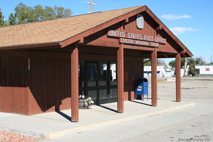
  Welcome to the Custer Montana Picture Tour

Join us as explore the Yellowstone River area around Custer, Montana the site of monumental Montana history.                Look Northeast across the Yellowstone River, from the town of Custer, Montana and you will see the location of Junction City. The town of Junction City was, for a brief six years, responsible for the transformation of Montana, the Territory to Montana, the State.  In 1877, the year following the Battle of the Little Big Horn (June 25,1876), the number of military forts and personal in the area increased dramatically. Beginning in 1877, Army troop strength grew from barely 700 soldiers prior to 1876 to 3,300.  At the same time, construction on five new Army forts began in earnest. The new forts were not rustic rough hewn log stockades, built by soldiers like you see in the movies. The forts begun in 1877, did not have defensive walls, instead they consisted of finished lumber and brick buildings that bordered a rectangular shaped Parade Ground. The new forts required skilled craftsmen and laborers that had to be imported labor from the Midwest.  To entice workers to travel west, the Army paid up to $2.16 per eight hour day, plus overtime. Housing and meals were also included. How many workers were needed?  During the construction of Fort Maginnis in 1880-81, one hundred and ninety-four workers from St Paul, Minnesota built the fort in a span of six months. 

Junction City

For six years the area around present day Custer, Montana, was bustling collection of soldiers, laborers, horse thieves, ox teams and lawlessness. It’s hard to picture it now but in 1883, the shipping town of Junction City had a population of five hundred.  The community had fourteen saloons, three dance houses and several stores. Before the railroad was introduced, steamboats built in the Midwest, came up the Yellowstone River regularly.  In 1878, nine steamers made 15 trips up the Yellowstone. Most of them came as far as Junction City but some went to Camp Bertie near Pompeys Pillar, while other steamboats under favorable conditions, got as far west as Huntley, Montana. From Junction City, ox drawn freighters and their drivers, aka “Bullwhackers,” hauled the goods North or South and as far west as Bozeman, Montana.

Hello Railroad, Goodbye Steamboats

Junction City located on the north bank of the Yellowstone River was a great place to unload steamboats but was too remote for the railroad.  During the construction of the railroad it was decided Custer, Montana on the South bank of the Yellowstone River was more accessible. Cutting off Junction City from the flow of goods meant the town’s days were numbered. The last steamer docked at Junction City in 1882.  In the 1883, the town of Junction City was almost completely destroyed by a fire. Today, little remains of historic town of Junction City. In 1909, the Editor of “The Eastern Slope,” Jean P. Decker wrote:   “Gone is Junction.  The few crazy shacks that mark the place where it was will soon disappear and only the name will linger until the present generation will have passed away, when it will be forgotten, but in the words of the old-timer, “she was a daisy while she lasted.”   *https://montanaconnectionspark.com/2019/10/13/transportation-history-of-montana-railways/

Army Forts that can trace their origin to Junction City & Custer, Montana

Fort Keogh (1876-1924) Located ninety-one miles from Junction City, west of present day Miles City, Montana.                             
Fort Custer (1877-1898) Located thirty miles from Junction City, west of present day Hardin, Montana. 
Fort Missoula (1877-1946) Located three hundred and seventy miles away, the fort’s history was not connected to Jct. City.
Fort Assiniboine (1879-1911) Located two hundred-sixty-two miles from Junction City, south of present day Havre, MT. 
Fort Maginnis (1880-1890) Located one hundred and forty miles from Junction City, east of present day Maiden, Montana
Fort McKinney (1877-1894) Located one hundred and forty-eight miles to the south near present day Buffalo, Wyoming.


Pompeys Pillar

Clark's Overlook (Dillon, Montana)

Traveler's Rest (Lolo, Montana)

Camp Disappointment (West of Shelby, Montana)

Great Falls, Montana

Pompeys Pillar Montana

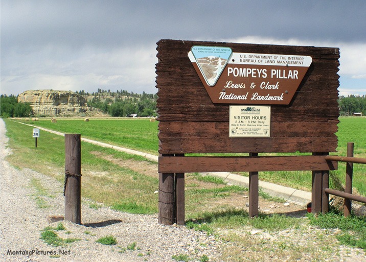
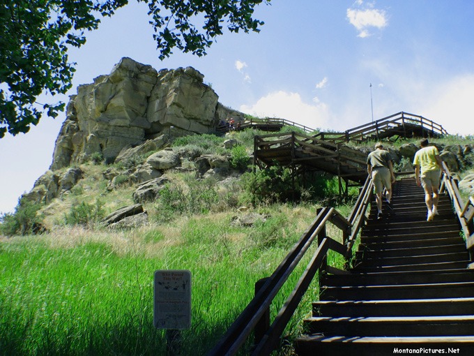
For decades, my family never seemed to be enough time to stop at the Lewis & Clark National Monument called Pompey’s Pillar. Located between Billings and Custer, Montana the historic 120-foot-tall sandstone formation bears the only remaining physical evidence of the Lewis and Clark Expedition.  Imagine what a thrill it was to finally use exit 23 off Interstate 94 and explore Pompey’s Pillar on the Yellowstone River.

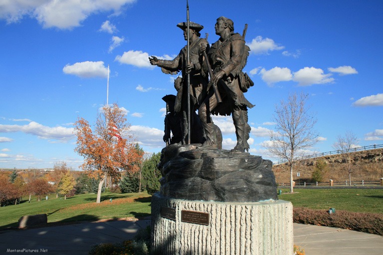
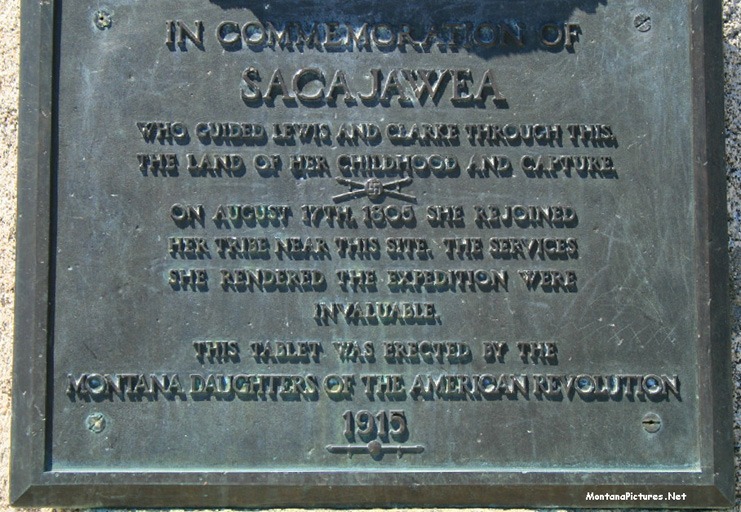
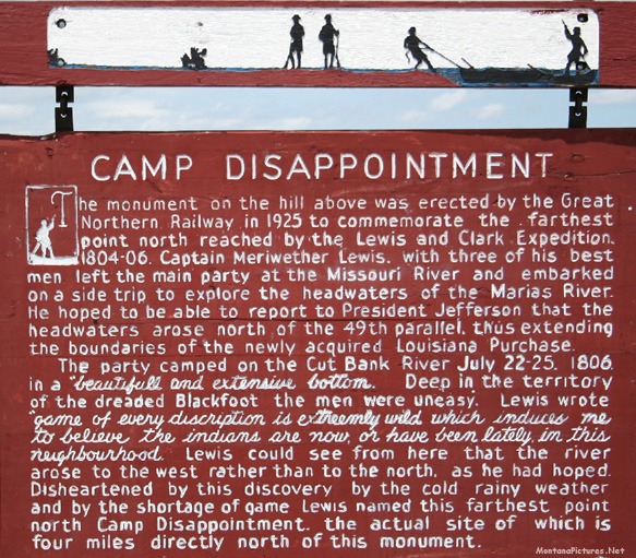
On July 3, 1806 south of present day Missoula, Lewis and nine men split from the of the party to further explore the Marias River area north of the Missouri River. Click here to see “Camp Disappointment” located east of Browning, Montana.   The remaining members continued under the leadership of Captain William Clark. Among Clark’s party of 23 people were interpreters, Toussaint Charbonneau, his Shoshoni wife, Sacajawea and the their baby Jean Baptiste (whom Clark called Pomp). At Three Forks, 10 of the 23 in Clark’s party turned north to rejoin Lewis. Click here to see the Missouri Rivers State Park.

The Place Where The Mountain Lion Lies

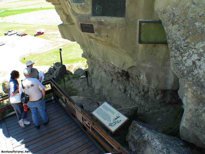
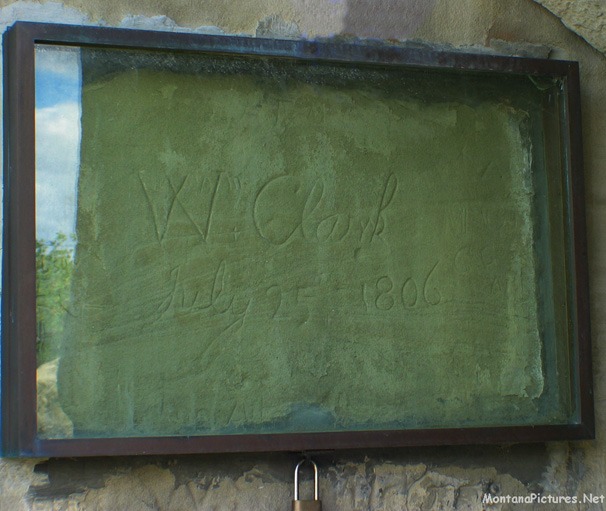
The remaining thirteen continued east. After travelling almost 200 miles the Clark party came across a unique sandstone formation on the Yellowstone River. the Native Americans called “the place where the mountain lion lies.” Some observers suggest that sandstone formation, that is part of the Pillar, which resembles a mountain lion’s head, is the reason for the name. Another theory cites live mountain lion being spotted in the area*. Seeing the hundreds of petroglyphs and markings left by travelers during the past 12,000 years must have inspired Clark to make his contribution. On July 25, 1806, Clark carved his name and date on the soft sandstone surface.  Captain Clark named the sandstone Pillar ”Pompy’s Tower” in honor of Sacajawea’s son Jean Baptiste Charbonneau. Nicholas Biddle, first editor of the Lewis and Clark journals, changed the name to “Pompeys Pillar.”  * https://www.pompeyspillar.org/

Want to see more petroglyphs and markings? Click here for the  Medicine Rocks State Park Picture Tour.